History Of India
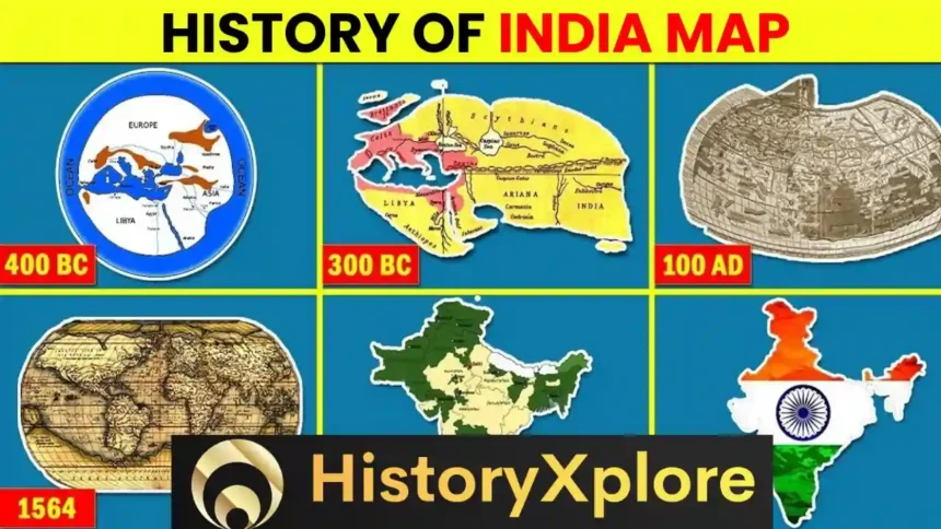
Do you know who made the first map of our India or when was this map prepared? And have you ever wondered who would have made the map of India and how? Friends, the map of any country shows a large part of that country in a small form. If there were no such maps then perhaps we would not have known what India or any other country looks like today. So in today’s video, I am going to tell you about the complete history of Indian Map and will also know about the World Map. So let’s start the video. Friends, because of some great people of the world today we know what our country looks like.
Many people in history have claimed that they were the first to draw the map of India, but names of only a few people have been given in Indian history. But first let us look at the world before India. Friends, the first map of the world was made by Imago Mundi. This map made on stone is about 26 years old. In this map, Mundy had shown the seven continents in a triangular shape and some important cities were also shown in it.
It is said that this map of Mundi was found in a desert in Iraq and today it is kept safe in a British Museum. After this, NFC is given the credit of making the first map of the world because the seven seas of the world were also shown in the map made by them. This map made in 540 BC may not be understandable to us today, but it was highly praised at that time and India was also shown for the first time in this map of a town made about 500 years ago. Firstly, he had worked on the map of the Annexe temple and in it he has shown many civilizations of the world area wise and today Taus is also called the Father of Geography.
After this, Eratosthenes made a world map at the behest of the famous Greek ruler Alexander. Actually, Alexander had to rule the whole world, for which he ordered Aristotle to make this world map 300 years ago. He presented India in his map in this way and also mentioned the Ganga River and Indus Valley Civilization. Friends, if anyone had made the most accurate map of the world till this time, it was Patole. Patole made the world map in round shape for the first time. He traveled to India 1900 years ago and as soon as he returned from the trip, he wrote a book and in this book a map was also found which was so beautiful that the people who saw it were stunned.
Up to this time it was the most accurate and precise map ever made. India was depicted well in his map. His map covered the entire Himalayan mountain range to South India and his map was praised all over the world. Even after this, many people traveled to India at different times and also tried to make different maps of the country. But the accurate map of India was made only in the modern period.
When European traders set out on a world tour to expand their trade and empire, the East India Company had already arrived in India and saw a lot of things here. Like the different types of crops growing in India, spices, the immense wealth of the kings here and much more. The British now wanted to achieve all this, for which it was very important for them to have a map of India. Due to which the British started trying to make a correct map of India so that they could capture India with the help of this map.
Friends, as I told you, India was mentioned in the world map for the first time by a friend and after that India was mentioned in every map of the world. Talking about the first map of India, very few people would know that James Rennell had tried to make the first map of India. He was appointed to the post of Survey of India of the East India Company. James Rennell surveyed the Ganga and Himalayan region in the year 1764 and then made its map. Using the maps made by him, the Bengal Atlas was later made in the year 1779.
After this, in the year 1783, he also made a map of entire India, but it had many flaws. It did not show the correct positions of the main places and there was a difference of 20 miles in the width of the sub-continents, but according to the sources and techniques available at that time, it was considered an excellent work and it was also highly praised. At this time in the 18th century the British had started ruling India. The British had defeated the ruler of Bengal, Siraj-ud-Daula, in the Battle of Plassey and now the British wanted to capture it and collect taxes from the people.
But due to lack of correct measurements at that time, they did not know the border area of Bengal. After which the British once again wanted to make a map of India and this time the responsibility of making the map of India was given to William Lemon. William London had deep knowledge of astrology, geography and mathematics and this was also a golden opportunity for him. At the behest of the East India Company, he started the survey of the Indian subcontinent in the year 1802.
This survey was started on 10 April 1802 and it was estimated that the entire India would be surveyed within five years. But it took the British 70 years to complete this survey. London started making the map of India from Madras located in the south of India and he used the simple triangle method for this and with the help of this device, London started making the map. But despite working continuously for 18 years, he could not complete even a large part of the map of India, after which he retired and then in his place George Everest was appointed Survey General of India in 1830.
Everest had formed a very big team and yet the work was going on at a very slow pace. This was because these people had to cross swollen rivers and dense forests. Due to which many people fell ill and sometimes had to face robbers and sometimes even wild animals. Due to these reasons, many people in the Everest team had to lose their lives but still the work of making the map continued. Let me tell you that there were mostly Indian people in this Everest team, but the work of these people was only to lift machines and tools, send signals, clean the forests, and measure the land with chains.
These were hired to help blacksmiths and cobblers repair tools and to guide people through forests or tribal areas, and to keep records in diaries for those who knew the English language. Indians were hired for many other similar jobs. Everest was greatly impressed by the two Indians in this team. Those people were Mohsin Hussain and Radhanath Sikandar. Both of them were very promising. By the year 1841, Everest had measured almost the entire land of India. That means the entire India from Kashmir to Kanyakumari had been measured. But here the Himalayan Mountain Range was very large, which started from Kashmir till Burma.
Everest had measured only a few of this mountain range, in which the percentage of measurements of Mount Everest, the highest mountain in the Himalayas, was correct. After this, George Everest also retired in 1843. After this, Andrew Scott Waugh came in his place. In the year 1843, he measured all the mountains of the Himalayan Mountain Range one by one and gave them Roman numbers.
And then in the year 1856, Andrew Scott announced that a peak in the Himalayan Mountain Range was the highest peak in the world and named it Mount Everest in honor of his former surveyor George Everest. During this time, the Karakoram mountain range was also discovered and many glaciers were also discovered and it was considered very important to find the sources of Ganga and Brahmaputra during this time. Friends, many historians say that the height of Mount Everest was not measured by George Everest but by his team member Radhanath Sikandar.
But being the Surveyor General, George Everest took the credit for it himself instead of giving it to Radhanath Sikandar. And that is why it would not be wrong at all to give credit to George Everest and William London for making an accurate map of India. Friends, at this time Tibet used to be a mysterious country and there was a ban on Europeans going here but Indians could go here and that is why the British government accepted two brothers living in India, Pandit Nain Singh and Pandit Kishan Singh, as monks.
Sent to Tibet so that they could know some information about Tibet. Between 1865 and 1892, these two brothers completed several expeditions and worked in Tibet for many years as a secret service. He traveled from Kathmandu in Nepal to Lhasa, the main city of Tibet and then to Lake Mansar and back from here. During the journey, both of them covered a distance of about 1200 zero miles. Both of them had discovered the trade route and water route to Tibet. Along with the land of Tibet, he also gave information about the people living there and the culture there.
After this he also traveled to Mongolia and collected very important information. And it was he who discovered that the origin of the Tsangpo River is Lake Manasarovar and the length of this river is 850 miles. For bringing so much information, Pandit Kishan Singh was given the title of Raibahadur. Then these two brothers trained many more Indians on how to conduct surveys and collect information. These included people like Kalyan Singh, Rigzin Namgyal, Ugyen, Jintao Mirza, Shuja, Ata Mohammad, Abdul Subhan and many more.
After which these people also went to many areas to collect information and after coming back they gave information about many new places. And this is the last map of India in which the whole of India is depicted, which was prepared after 70 years of hard work of thousands of Indians and many British officers and by this time India included Pakistan, Bangladesh, Burma which is today called Myanmar. Yes, everyone was involved. So friends, this was the complete history of the Indian map,
Anyway, see you again with the powerful explanation of the History.


